 Henry's Fork in Caribou-Targhee National Forest" fetchpriority="high" decoding="async">
The byway, at a glance
The Mesa Falls Scenic Byway is a 28-mile loop in eastern Idaho that connects Ashton to Island Park via Idaho Highway 47. It’s designated a National Scenic Byway by the Federal Highway Administration. The signature stops are Upper Mesa Falls (114 feet) and Lower Mesa Falls (65 feet) — the last two undammed major waterfalls on the Snake River system (Visit Idaho).
The full loop takes about 90 minutes of driving without stops, or 3–4 hours with the major pullouts and the falls walk. Most visitors do this as a half-day from Island Park.
Best season: late May through October. The byway is open year-round in dry conditions but the Upper Falls site (interpretive center, boardwalks, restrooms) closes in winter.
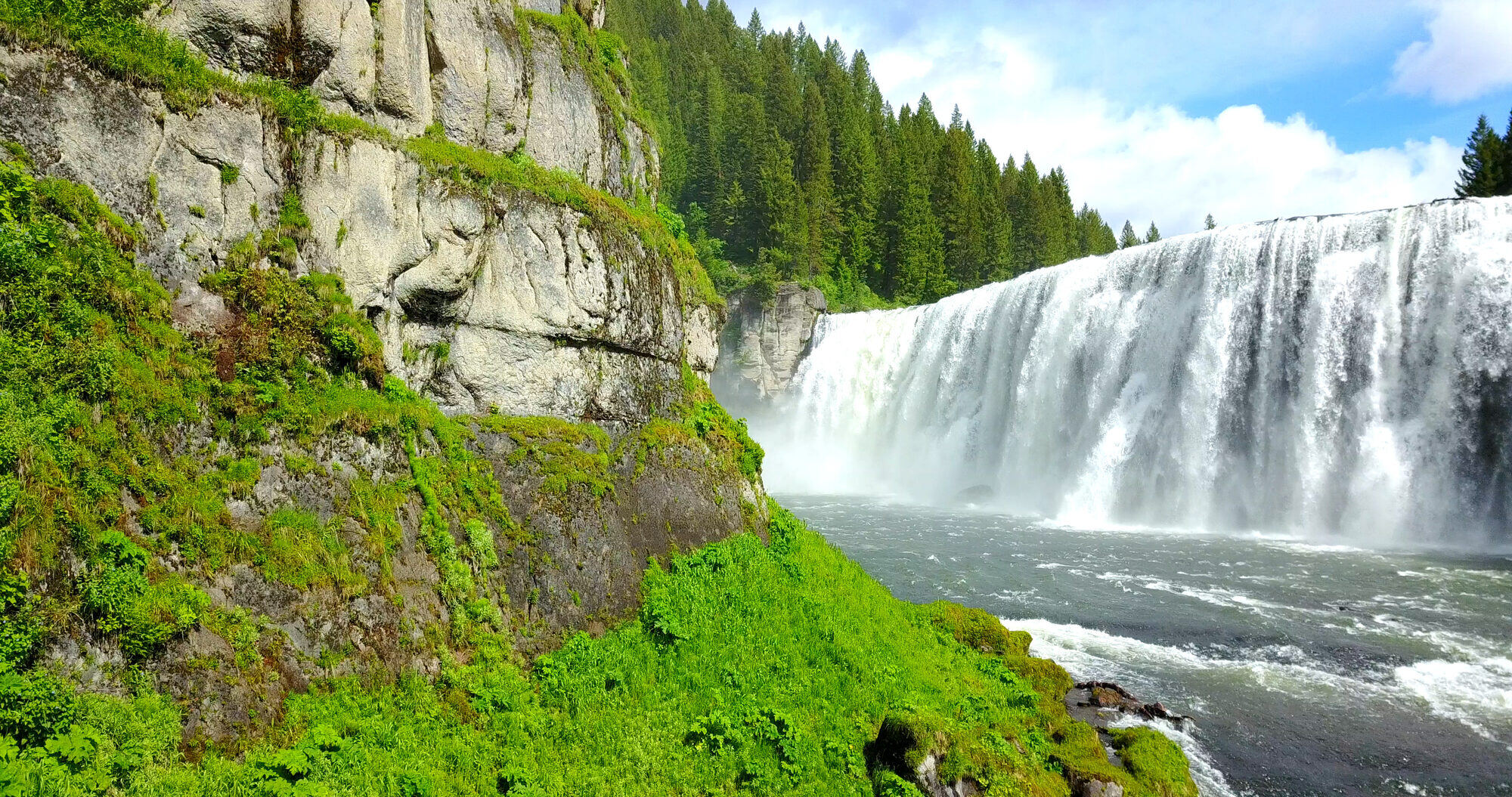
Upper Mesa Falls
What you see
114 feet of vertical drop. The Henry’s Fork river thundering over a perfectly horizontal lip of Mesa Falls Tuff — the volcanic ash sheet from a 1.3 million-year-old eruption that filled this entire region. The constancy of the lip (it doesn’t step or angle) makes Upper Mesa one of the most visually clean major waterfalls in the West.
Facilities
- Built viewing platforms with stairs leading toward the brink of the falls
- Some pathways and platforms are universally accessible
- Big Falls Inn — restored 1915 lodge, now a seasonal interpretive center. Open approximately May 15 through October 1.
- Picnic area, restrooms (pit toilets when interpretive center is closed; flush toilets in summer)
- Trail to Lower Falls overlook (1-mile round-trip)
Fees and hours
- Hours (summer): 9:30 AM – 5:30 PM daily
- Day-use fee: $5 per vehicle, $1 for motorcycles / bicycles / horses / hikers
- Winter access is free but the site is unstaffed and most facilities are closed
Confirm seasonal hours and fee at Recreation.gov.
Lower Mesa Falls
65 feet. Viewable from Grandview Overlook, about a quarter-mile up the road from the Upper Falls site. There’s no trail down to the base — the overlook is the only public viewing point. The view is excellent: you see the full falls plus the canyon downstream.
Free, year-round access. The overlook has limited parking and pit toilets.
If you have time for only one stop on the byway: do Upper Falls. If you can do both: do Upper first, then drive to Grandview Overlook (just minutes away) for Lower.
The route, stop by stop
The byway is best driven north-to-south (Island Park → Ashton) or south-to-north (Ashton → Island Park). The stops below are listed north-to-south.
Stop 1: Island Park (start point)
Fuel up, grab coffee. Leave US-20 at the Idaho 47 junction and head east-southeast.
Stop 2: Bear Gulch (optional)
A small pullout with view of the Henry’s Fork canyon. Good photo stop, brief leg-stretch. No facilities.
Stop 3: Upper Mesa Falls
The main event. Plan 60–90 minutes for the boardwalks, interpretive center (in season), and to walk to the brink of the falls.
Stop 4: Grandview Overlook (Lower Mesa Falls)
Quarter-mile south of Upper Falls. Quick 15-minute stop.
Stop 5: Ashton overlook descent
The road drops out of the high country toward Ashton with several pullouts offering long views of the Snake River plain and the Tetons to the southeast (clear days). 15–30 minutes of driving with stops.
Stop 6: Ashton
End point. Small town with a few restaurants, the Broulim’s grocery (the closest real grocery to Island Park — useful for stocking up on the way back). The Henry’s Fork Foundation office is here, open weekday business hours.
Best time to go
Summer (June – August)
Falls volume is highest in June (peak runoff), tapering through summer. The interpretive center is staffed and open. Wildflowers in July. Most crowded on summer weekends — midweek is calmer.
Fall (September – mid-October)
Many visitors’ favorite season. Aspens turn gold mid-September through early October. Fewer crowds. Volume on the falls is still substantial. The interpretive center closes around October 1 — verify before going.
Winter
The byway road is plowed in winter but the Upper Falls site closes. Falls themselves remain partially visible (ice formations are striking) but access is to the parking area only; boardwalks past the gate are closed.
Spring (late April – May)
Mud season. Falls flow is just beginning to peak. Interpretive center reopens May 15.
Time of day
Late morning to mid-afternoon for the best light on the falls. Early morning produces soft side-light but the canyon is in shadow. Sunset light hits the upper portion of Upper Falls but the base is in shade by then.
What to combine it with
Henry's Fork Foundation visit (Ashton)
End point of the byway, business hours weekdays. The conservation organization that protects the Henry's Fork — they have informational displays and staff who'll talk to visitors about river ecology.
Float trip on the Henry's Fork
The Big Springs to Mack's Inn float is best done as a morning, with the byway as an afternoon. Reverse it in fall when water is too cold to float comfortably.
Yellowstone day
The byway makes a strong second-day alternative after a full Yellowstone day — less driving, no entrance fee, similar geological storytelling but on a smaller scale.
Fly fishing the Mesa Falls section
The Henry’s Fork above and below the falls is fishable. The water below Mesa Falls is structurally different from the Island Park sections — warmer, more pastoral. Day-trip fishing from the byway access is feasible if you bring gear.
Questions, answered
How long does the byway take to drive?
90 minutes nonstop. Plan 3–4 hours with both Falls stops and a few pullouts. Half-day from Island Park including drive in and out.
Is the falls overlook stroller-accessible?
Upper Falls has some universally accessible pathways including a paved trail to the main upper-river overlook. The lower platforms and the trail to the brink involve stairs.
Can I swim or wade at the base of the falls?
No. The cliffs around Upper Mesa Falls are protected, and water below the falls is dangerous (deep pool, undercurrents). Stay on the overlooks.
Is the interpretive center worth stopping in?
Yes if it’s open. The Big Falls Inn building itself is a restored 1915 hotel — worth seeing for the building alone. The interpretive displays cover geology and homesteader history.
Where do I fuel up before the drive?
Pond’s Lodge area in Island Park (north end), Sawtelle Peak Road Sinclair (mid Island Park), or in Ashton on the south end. There is no fuel along the byway itself between Island Park and Ashton.